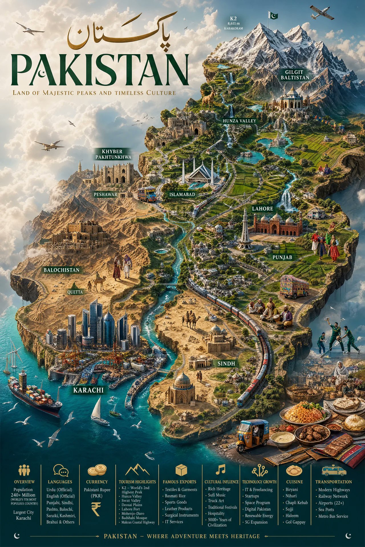
Pakistan Miniature World Map Poster
Create an ultra-detailed hyper-realistic 9:16 cinematic miniature world map of Pakistan, designed as a premium luxury travel-poster masterpiece where the entire country appears as
- Category
- Photography & Realism
- Model
- GPT Image 2
- Creator
- EvoLinkAI
- Source language
- en
- Source ID
- portrait-245
Full prompt
Create an ultra-detailed hyper-realistic 9:16 cinematic miniature world map of Pakistan, designed as a premium luxury travel-poster masterpiece where the entire country appears as a massive handcrafted floating island civilization suspended in soft atmospheric clouds. The terrain must showcase dramatic elevation and geographic diversity, including the towering snow-covered peaks of the Karakoram and Himalayas (featuring K2), lush green valleys of Hunza and Swat, dense forests, glowing rivers like the Indus, crystal-blue coastlines along the Arabian Sea, cascading waterfalls, expansive deserts like Thar and Cholistan, fertile farmland of Punjab, and serene lakes. Include futuristic cities blended with historical richness: Karachi as a sprawling coastal megacity with glowing harbor lights.
Translations
Pakistan Miniature World Map Poster
enCreate an ultra-detailed hyper-realistic 9:16 cinematic miniature world map of Pakistan, designed as a premium luxury travel-poster masterpiece where the entire country appears as a massive handcrafted floating island civilization suspended in soft atmospheric clouds. The terrain must showcase dramatic elevation and geographic diversity, including the towering snow-covered peaks of the Karakoram and Himalayas (featuring K2), lush green valleys of Hunza and Swat, dense forests, glowing rivers like the Indus, crystal-blue coastlines along the Arabian Sea, cascading waterfalls, expansive deserts like Thar and Cholistan, fertile farmland of Punjab, and serene lakes. Include futuristic cities blended with historical richness: Karachi as a sprawling coastal megacity with glowing harbor lights.