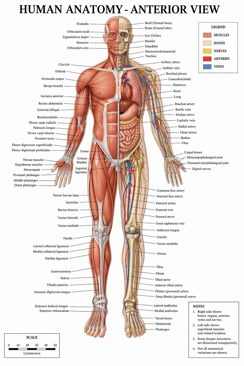
大气环流教育信息图
生成一份详细的多板块教育信息图,适用于教科书,包含图表、要点说明及真实世界的摄影示例。
- Category
- Charts & Infographics
- Model
- GPT Image 2
- Creator
- WY
- Source language
- en
- Source ID
- 13753
- Published
- Apr 16, 2026
Full prompt
{
"type": "educational infographic",
"style": "clean, modern textbook illustration, light blue and white color palette",
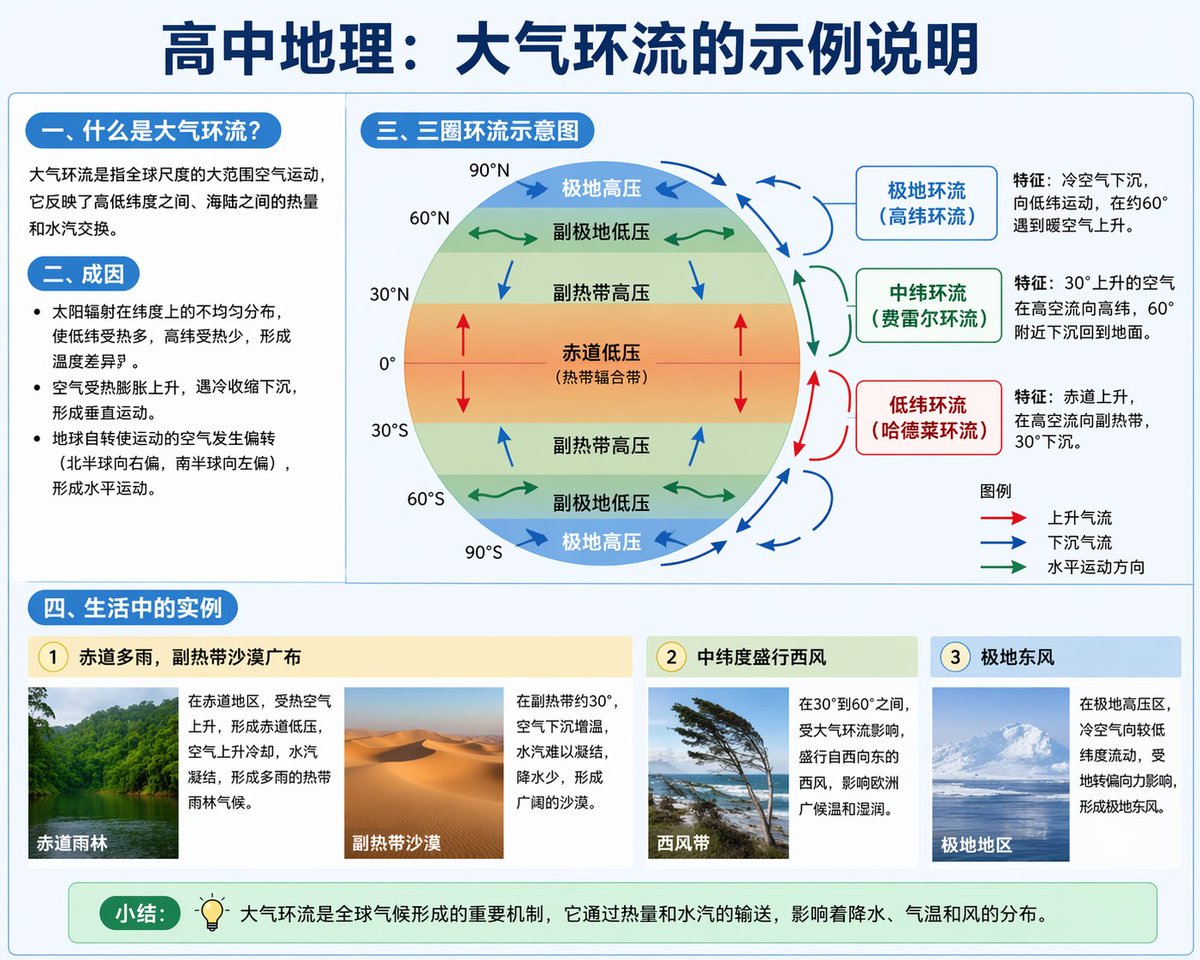
"header": "{argument name=\"main title\" default=\"高中地理:大气环流的示例说明\"}",
"layout": {
"top_left_column": {
"section_1": {
"title": "{argument name=\"section one title\" default=\"一、什么是大气环流?\"}",
"content": "1 short explanatory paragraph about global air movement"
},
"section_2": {
"title": "二、成因",
"content": "3 bullet points explaining solar radiation, vertical movement, and Coriolis effect"
}
},
"top_right_column": {
"section_3": {
"title": "{argument name=\"diagram title\" default=\"三、三圈环流示意图\"}",
"diagram_features": [
"Earth cross-section showing latitudes 0 to 90 degrees North and South",
"Color-coded pressure belts: red (equator), yellow (subtropics), green (subpolar), blue (polar)",
"Arrows indicating air flow directions"
],
"circulation_cells": {
"count": 3,
"labels": ["极地环流 (高纬环流)", "中纬环流 (费雷尔环流)", "低纬环流 (哈德莱环流)"],
"descriptions": "3 text boxes detailing characteristics of each cell"
},
"legend": {
"title": "图例",
"items": "3 arrow types: red (ascending), blue (descending), green (horizontal)"
}
}
},
"bottom_row": {
"section_4": {
"title": "{argument name=\"examples title\" default=\"四、生活中的实例\"}",
"examples": {
"count": 3,
"items": [
{
"subtitle": "1 赤道多雨,副热带沙漠广布",
"images": "2 photos: tropical rainforest and desert",
"text": "2 text blocks explaining the climates"
},
{
"subtitle": "2 中纬度盛行西风",
"images": "1 photo: windswept trees on a coast",
"text": "1 text block explaining westerlies"
},
{
"subtitle": "3 极地东风",
"images": "1 photo: snowy mountains",
"text": "1 text block explaining polar easterlies"
}
]
}
}
},
"footer": {
"label": "{argument name=\"footer label\" default=\"小结:\"}",
"icon": "lightbulb",
"content": "1 summary sentence about global climate mechanisms"
}
}
}Translations
大气环流教育信息图
en{ "type": "educational infographic", "style": "clean, modern textbook illustration, light blue and white color palette", "header": "{argument name=\"main title\" default=\"高中地理:大气环流的示例说明\"}", "layout": { "top_left_column": { "section_1": { "title": "{argument name=\"section one title\" default=\"一、什么是大气环流?\"}", "content": "1 short explanatory paragraph about global air movement" }, "section_2": { "title": "二、成因", "content": "3 bullet points explaining solar radiation, vertical movement, and Coriolis effect" } }, "top_right_column": { "section_3": { "title": "{argument name=\"diagram title\" default=\"三、三圈环流示意图\"}", "diagram_features": [ "Earth cross-section showing latitudes 0 to 90 degrees North and South", "Color-coded pressure belts: red (equator), yellow (subtropics), green (subpolar), blue (polar)", "Arrows indicating air flow directions" ], "circulation_cells": { "count": 3, "labels": ["极地环流 (高纬环流)", "中纬环流 (费雷尔环流)", "低纬环流 (哈德莱环流)"], "descriptions": "3 text boxes detailing characteristics of each cell" }, "legend": { "title": "图例", "items": "3 arrow types: red (ascending), blue (descending), green (horizontal)" } } }, "bottom_row": { "section_4": { "title": "{argument name=\"examples title\" default=\"四、生活中的实例\"}", "examples": { "count": 3, "items": [ { "subtitle": "1 赤道多雨,副热带沙漠广布", "images": "2 photos: tropical rainforest and desert", "text": "2 text blocks explaining the climates" }, { "subtitle": "2 中纬度盛行西风", "images": "1 photo: windswept trees on a coast", "text": "1 text block explaining westerlies" }, { "subtitle": "3 极地东风", "images": "1 photo: snowy mountains", "text": "1 text block explaining polar easterlies" } ] } } }, "footer": { "label": "{argument name=\"footer label\" default=\"小结:\"}", "icon": "lightbulb", "content": "1 summary sentence about global climate mechanisms" } } }
大气环流教育信息图
zh-CN{ "type": "教育信息图", "style": "简洁、现代的教科书插图风格,采用浅蓝与白色配色方案", "header": "{argument name=\"main title\" default=\"高中地理:大气环流的示例说明\"}", "layout": { "top_left_column": { "section_1": { "title": "{argument name=\"section one title\" default=\"一、什么是大气环流?\"}", "content": "1 段关于全球空气运动的简短解释" }, "section_2": { "title": "二、成因", "content": "3 个要点,解释太阳辐射、垂直运动和地转偏向力" } }, "top_right_column": { "section_3": { "title": "{argument name=\"diagram title\" default=\"三、三圈环流示意图\"}", "diagram_features": [ "显示南北纬 0 度至 90 度的地球横截面", "颜色编码的气压带:红色(赤道)、黄色(副热带)、绿色(副极地)、蓝色(极地)", "指示气流方向的箭头" ], "circulation_cells": { "count": 3, "labels": ["极地环流 (高纬环流)", "中纬环流 (费雷尔环流)", "低纬环流 (哈德莱环流)"], "descriptions": "3 个文本框,详细说明每个环流圈的特征" }, "legend": { "title": "图例", "items": "3 种箭头类型:红色(上升)、蓝色(下沉)、绿色(水平)" } } }, "bottom_row": { "section_4": { "title": "{argument name=\"examples title\" default=\"四、生活中的实例\"}", "examples": { "count": 3, "items": [ { "subtitle": "1 赤道多雨,副热带沙漠广布", "images": "2 张照片:热带雨林和沙漠", "text": "2 个解释气候的文本块" }, { "subtitle": "2 中纬度盛行西风", "images": "1 张照片:海岸边被风吹弯的树木", "text": "1 个解释西风带的文本块" }, { "subtitle": "3 极地东风", "images": "1 张照片:雪山", "text": "1 个解释极地东风带的文本块" } ] } } }, "footer": { "label": "{argument name=\"footer label\" default=\"小结:\"}", "icon": "lightbulb", "content": "1 句关于全球气候机制的总结" } } }