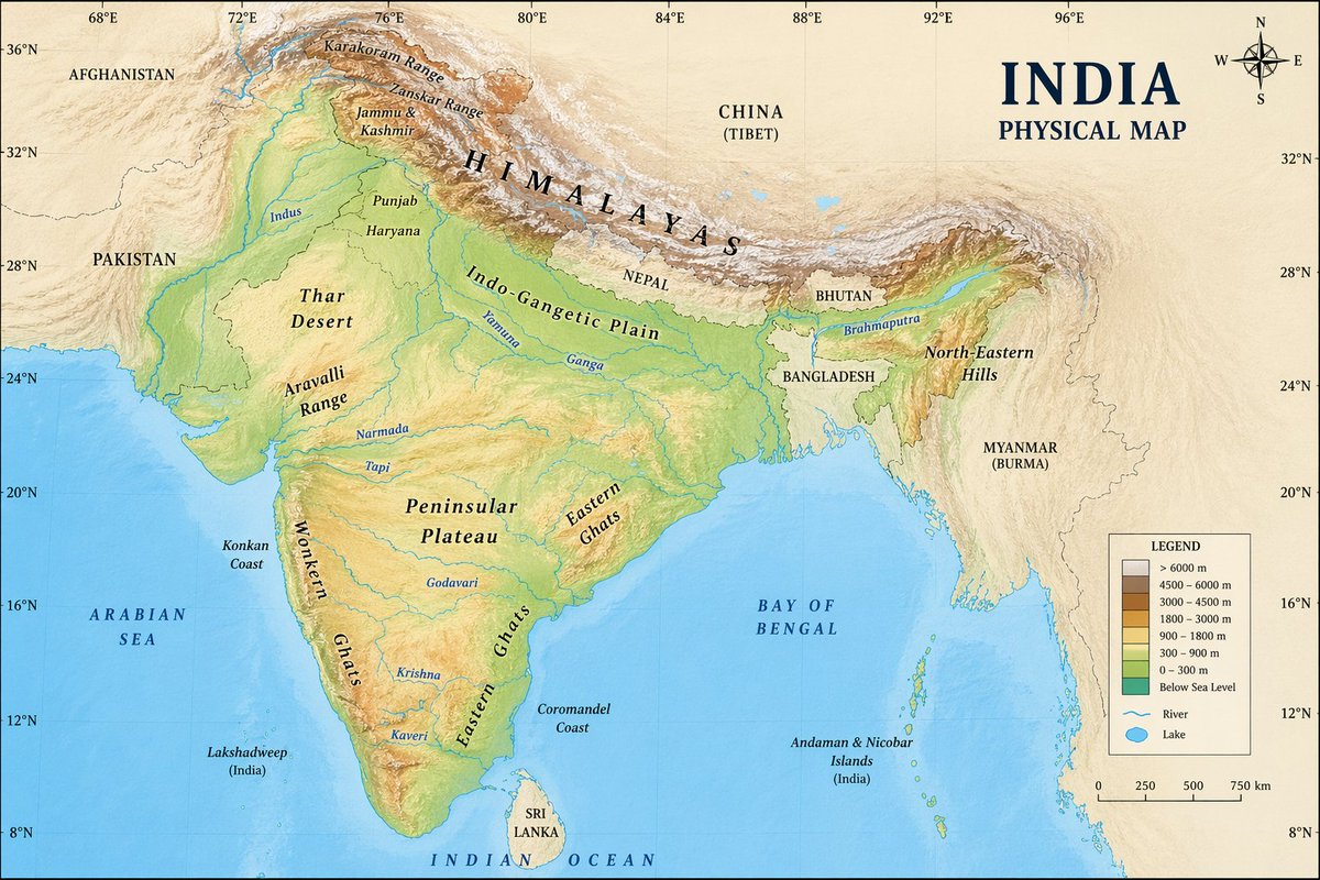
大本钟区域卫星地图
此提示词可生成一张以大本钟和威斯敏斯特宫为中心的逼真标注式卫星航拍地图,适用于地图对比、地理位置可视化及地理背景图像。
- Category
- Charts & Infographics
- Model
- GPT Image 2
- Creator
- fofr
- Source language
- en
- Source ID
- 14409
- Published
- Apr 21, 2026
Full prompt
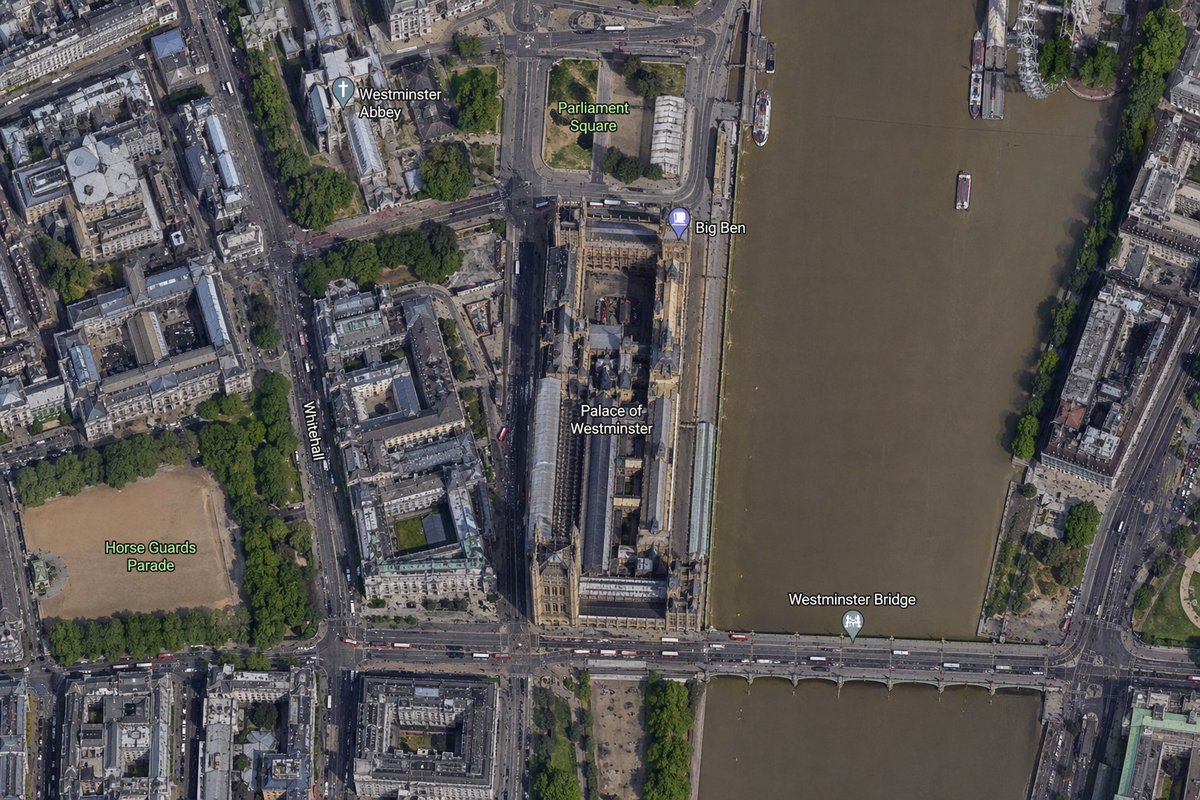
A high-resolution top-down satellite map view of central {argument name="city" default="London"}, focused tightly on the area around {argument name="landmark" default="Big Ben"} and the Palace of Westminster beside the River Thames. Show a realistic aerial orthographic perspective like a modern digital map or satellite layer, with detailed rooftops, streets, trees, shadows, and brownish river water. Place the long Palace of Westminster complex vertically near the center-right, directly along the west bank of the river, with Big Ben at the northeast corner of the palace near the river edge. A bridge labeled {argument name="bridge name" default="Westminster Bridge"} crosses horizontally near the bottom of the frame from left to right over the river. Include 6 visible map labels total: {argument name="label 1" default="Westminster Abbey"}, {argument name="label 2" default="Parliament Square"}, Big Ben, Palace of Westminster, Westminster Bridge, and Horse Guards Parade. Also show Whitehall as a labeled road running vertically on the left side of the palace area. Surrounding details should include Westminster Abbey in the upper left quadrant, Parliament Square above the palace, Horse Guards Parade as a large sandy rectangular ground in the lower left quadrant, dense city blocks and roads on the left half, the River Thames occupying the full right side, embankments on both sides, a few boats on the river, and tree-lined streets and parks. Use natural satellite-image colors, crisp cartographic label overlays, and the look of a zoomed-in online maps screenshot.Translations
大本钟区域卫星地图
enA high-resolution top-down satellite map view of central {argument name="city" default="London"}, focused tightly on the area around {argument name="landmark" default="Big Ben"} and the Palace of Westminster beside the River Thames. Show a realistic aerial orthographic perspective like a modern digital map or satellite layer, with detailed rooftops, streets, trees, shadows, and brownish river water. Place the long Palace of Westminster complex vertically near the center-right, directly along the west bank of the river, with Big Ben at the northeast corner of the palace near the river edge. A bridge labeled {argument name="bridge name" default="Westminster Bridge"} crosses horizontally near the bottom of the frame from left to right over the river. Include 6 visible map labels total: {argument name="label 1" default="Westminster Abbey"}, {argument name="label 2" default="Parliament Square"}, Big Ben, Palace of Westminster, Westminster Bridge, and Horse Guards Parade. Also show Whitehall as a labeled road running vertically on the left side of the palace area. Surrounding details should include Westminster Abbey in the upper left quadrant, Parliament Square above the palace, Horse Guards Parade as a large sandy rectangular ground in the lower left quadrant, dense city blocks and roads on the left half, the River Thames occupying the full right side, embankments on both sides, a few boats on the river, and tree-lined streets and parks. Use natural satellite-image colors, crisp cartographic label overlays, and the look of a zoomed-in online maps screenshot.
大本钟区域卫星地图
zh-CN一张以 {argument name="city" default="伦敦"} 市中心为核心的高分辨率俯视卫星地图,紧密聚焦于 {argument name="landmark" default="大本钟"} 及泰晤士河畔威斯敏斯特宫周边区域。呈现出现代数字地图或卫星图层般的逼真航拍正射视角,包含详细的屋顶、街道、树木、阴影及棕褐色的河水。将长条形的威斯敏斯特宫建筑群垂直放置在画面中右侧,紧邻河流西岸,大本钟位于宫殿东北角靠近河岸的位置。一座标注为 {argument name="bridge name" default="威斯敏斯特桥"} 的桥梁在画面底部从左至右横跨河流。总共包含 6 个可见地图标签:{argument name="label 1" default="威斯敏斯特教堂"}、{argument name="label 2" default="议会广场"}、大本钟、威斯敏斯特宫、威斯敏斯特桥和骑兵卫队阅兵场。同时将白厅作为一条标注道路,垂直显示在宫殿区域左侧。周边细节应包括左上象限的威斯敏斯特教堂、宫殿上方的议会广场、左下象限作为大型沙色长方形场地的骑兵卫队阅兵场、左半部分密集的城市街区与道路、占据整个右侧的泰晤士河、两岸的堤岸、河上的少量船只以及绿树成荫的街道与公园。采用自然的卫星图像色彩、清晰的地图标注叠加层,呈现出放大后的在线地图截图效果。