纽约夜景档案立体模型
生成博物馆级的夜间建筑档案项目,展示纽约市的 3D 浮雕地图模型,包含标签、图例和逼真的材质。
- Category
- Charts & Infographics
- Model
- GPT Image 2
- Creator
- Tia
- Source language
- en
- Source ID
- 20069
- Published
- May 13, 2026
Full prompt
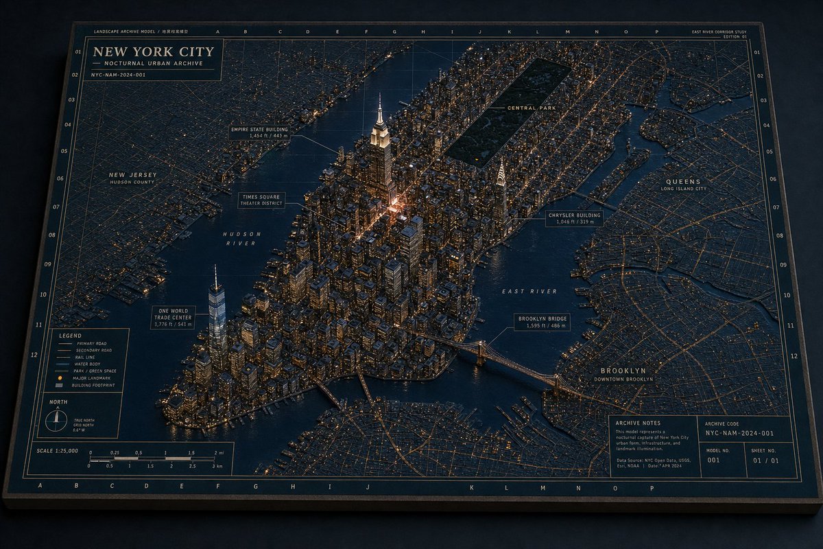
Goal: Create a highly detailed physical “Landscape Archive Model” museum diorama of {argument name="city name" default="New York City"} at night, presented as an architectural archive board with a raised 3D city model integrated into a flat cartographic map.

Canvas: Wide horizontal 16:9 image, photographed from an oblique overhead angle like a premium editorial product shot. The board sits on a dark surface with subtle shadows, a thick matte edge, and tactile paper/cardboard texture. Use a restrained night palette of deep navy, charcoal blue, muted brass, warm amber window lights, cream annotation lines, and dark green park areas.

Layout: The entire image is one large rectangular archive plate with a thin double-line border, coordinate grid letters along the top and bottom, coordinate numbers along both sides, and faint technical map grid lines. The central area shows Manhattan as a dense raised miniature city, surrounded by darker flat-map boroughs and waterways. The 3D buildings should look like matte architectural model blocks with tiny lit windows and cast shadows. The waterways are dark blue, slightly satin, and labeled directly on the map.

Main title block: Place a boxed title panel in the upper left reading exactly “NEW YORK CITY”, with smaller lines “NOCTURNAL URBAN ARCHIVE” and “NYC-NAM-2024-001”. Add tiny archive text above it such as “LANDSCAPE ARCHIVE MODEL / 地景档案模型”. Add a small top-right study label reading “EAST RIVER CORRIDOR STUDY” and “EDITION 01”.

Subject details: Show Manhattan as the main raised island, packed with hundreds of small buildings and warm light points. Include a tall glowing Empire State Building near midtown, a bright cluster around Times Square, One World Trade Center near lower Manhattan, the Chrysler Building on the east side, Brooklyn Bridge crossing the East River, and a rectangular dark Central Park inset near the top-center of Manhattan. Surrounding flat-map areas should include New Jersey on the left, Queens on the right, and Brooklyn in the lower right.

Counted visible map labels: Include exactly 15 prominent callouts/region labels: 1) “NEW JERSEY / HUDSON COUNTY”, 2) “HUDSON RIVER”, 3) “ONE WORLD TRADE CENTER / 1,776 ft / 541 m”, 4) “TIMES SQUARE / THEATER DISTRICT”, 5) “EMPIRE STATE BUILDING / 1,454 ft / 443 m”, 6) “CENTRAL PARK”, 7) “CHRYSLER BUILDING / 1,046 ft / 319 m”, 8) “EAST RIVER”, 9) “BROOKLYN BRIDGE / 1,595 ft / 486 m”, 10) “QUEENS / LONG ISLAND CITY”, 11) “BROOKLYN / DOWNTOWN BROOKLYN”, 12) “LEGEND”, 13) “NORTH”, 14) “SCALE 1:25,000”, 15) “ARCHIVE NOTES”. Use thin cream leader lines and small boxed annotation plates for landmark callouts.

Legend and information panels: In the lower left, create one boxed legend with exactly 6 legend entries: “PRIMARY ROAD”, “SECONDARY ROAD”, “RAIL LINE”, “WATER BODY”, “PARK / GREEN SPACE”, and “MAJOR LANDMARK / BUILDING FOOTPRINT”. Below or near it, include one small north arrow compass and one scale bar labeled in miles and kilometers. In the lower right, create one archive notes box with a paragraph of tiny technical text plus exactly 4 metadata fields: “ARCHIVE CODE NYC-NAM-2024-001”, “MODEL NO. 001”, “SHEET NO. 01 / 01”, and data-source text in very small print.

Visual style: Ultra-realistic miniature architectural model photography mixed with precise cartographic design, museum archive aesthetic, sharp details, physical paper grain, slightly worn board edges, amber pinprick lights, clean serif title typography, tiny monospaced technical labels, and dramatic but soft nocturnal studio lighting.

Constraints: Keep the image as a single finished physical archive board, not a digital UI. Maintain exact visible landmark hierarchy and the listed label count. No people, vehicles, logos, watermark, or extra decorative text. Preserve the nighttime restrained color palette and the tactile model-map hybrid look.
Translations
纽约夜景档案立体模型
enGoal: Create a highly detailed physical “Landscape Archive Model” museum diorama of {argument name="city name" default="New York City"} at night, presented as an architectural archive board with a raised 3D city model integrated into a flat cartographic map. Canvas: Wide horizontal 16:9 image, photographed from an oblique overhead angle like a premium editorial product shot. The board sits on a dark surface with subtle shadows, a thick matte edge, and tactile paper/cardboard texture. Use a restrained night palette of deep navy, charcoal blue, muted brass, warm amber window lights, cream annotation lines, and dark green park areas. Layout: The entire image is one large rectangular archive plate with a thin double-line border, coordinate grid letters along the top and bottom, coordinate numbers along both sides, and faint technical map grid lines. The central area shows Manhattan as a dense raised miniature city, surrounded by darker flat-map boroughs and waterways. The 3D buildings should look like matte architectural model blocks with tiny lit windows and cast shadows. The waterways are dark blue, slightly satin, and labeled directly on the map. Main title block: Place a boxed title panel in the upper left reading exactly “NEW YORK CITY”, with smaller lines “NOCTURNAL URBAN ARCHIVE” and “NYC-NAM-2024-001”. Add tiny archive text above it such as “LANDSCAPE ARCHIVE MODEL / 地景档案模型”. Add a small top-right study label reading “EAST RIVER CORRIDOR STUDY” and “EDITION 01”. Subject details: Show Manhattan as the main raised island, packed with hundreds of small buildings and warm light points. Include a tall glowing Empire State Building near midtown, a bright cluster around Times Square, One World Trade Center near lower Manhattan, the Chrysler Building on the east side, Brooklyn Bridge crossing the East River, and a rectangular dark Central Park inset near the top-center of Manhattan. Surrounding flat-map areas should include New Jersey on the left, Queens on the right, and Brooklyn in the lower right. Counted visible map labels: Include exactly 15 prominent callouts/region labels: 1) “NEW JERSEY / HUDSON COUNTY”, 2) “HUDSON RIVER”, 3) “ONE WORLD TRADE CENTER / 1,776 ft / 541 m”, 4) “TIMES SQUARE / THEATER DISTRICT”, 5) “EMPIRE STATE BUILDING / 1,454 ft / 443 m”, 6) “CENTRAL PARK”, 7) “CHRYSLER BUILDING / 1,046 ft / 319 m”, 8) “EAST RIVER”, 9) “BROOKLYN BRIDGE / 1,595 ft / 486 m”, 10) “QUEENS / LONG ISLAND CITY”, 11) “BROOKLYN / DOWNTOWN BROOKLYN”, 12) “LEGEND”, 13) “NORTH”, 14) “SCALE 1:25,000”, 15) “ARCHIVE NOTES”. Use thin cream leader lines and small boxed annotation plates for landmark callouts. Legend and information panels: In the lower left, create one boxed legend with exactly 6 legend entries: “PRIMARY ROAD”, “SECONDARY ROAD”, “RAIL LINE”, “WATER BODY”, “PARK / GREEN SPACE”, and “MAJOR LANDMARK / BUILDING FOOTPRINT”. Below or near it, include one small north arrow compass and one scale bar labeled in miles and kilometers. In the lower right, create one archive notes box with a paragraph of tiny technical text plus exactly 4 metadata fields: “ARCHIVE CODE NYC-NAM-2024-001”, “MODEL NO. 001”, “SHEET NO. 01 / 01”, and data-source text in very small print. Visual style: Ultra-realistic miniature architectural model photography mixed with precise cartographic design, museum archive aesthetic, sharp details, physical paper grain, slightly worn board edges, amber pinprick lights, clean serif title typography, tiny monospaced technical labels, and dramatic but soft nocturnal studio lighting. Constraints: Keep the image as a single finished physical archive board, not a digital UI. Maintain exact visible landmark hierarchy and the listed label count. No people, vehicles, logos, watermark, or extra decorative text. Preserve the nighttime restrained color palette and the tactile model-map hybrid look.
纽约夜景档案立体模型
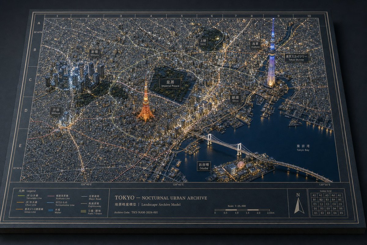
zh-CN目标:创建一个高度精细的物理博物馆立体模型风格的城市档案地图,主题为 {argument name="city name" default="New York City"} 的夜景,标题为“景观档案模型 / 夜间城市档案”。图像应呈现为一张经过摄影的、手工制作的建筑档案项目:底座为平面印刷地图,上方浮现出 3D 微缩城市模型,由微小的暖色建筑灯光和冷色调海军蓝环境光照亮。 画布:宽屏 16:9 风景摄影,四分之三俯视视角,整个矩形档案项目完整呈现在深色桌面上。使用深海军蓝、炭灰、黄铜和暖琥珀色调。项目带有厚实的深色边框、细腻的纸张纹理、斜切边缘、投影效果以及博物馆模型般的真实质感。 布局:将曼哈顿的 3D 微缩模型置于中心,周围环绕着平面的雕刻地图区域和水道。河流应呈现为深光泽蓝色,带有细微的反射。背景地图包含精细的街道网格、坐标线、经纬度风格的引导标记以及档案边框编号。添加精确的顶部和侧面网格系统,顶部和底部标有字母,左右边缘标有数字。包含连接标签与地标的细黄铜注释线。 主体细节:将曼哈顿展示为密集且隆起的微缩建筑群,窗户散发着光芒。帝国大厦(Empire State Building)应在中心附近高耸,塔尖灯光璀璨。在曼哈顿左下区域包含世界贸易中心一号大楼(One World Trade Center),中城右侧为克莱斯勒大厦(Chrysler Building),时代广场(Times Square)作为发光的中心区域,中央公园(Central Park)表现为曼哈顿上城的一块深色矩形绿黑色空地,布鲁克林大桥(Brooklyn Bridge)横跨东河(East River)通往布鲁克林。周围行政区和区域标签应平铺在地图上。 文本内容与标签:使用优雅的米白色和黄铜色大写档案字体。包含 18 个可见的标签/注释元素:1) 主标题“NEW YORK CITY”,2) 副标题“NOCTURNAL URBAN ARCHIVE”,3) 档案 ID “NYC-NAM-2024-001”,4) 顶部微型标签“LANDSCAPE ARCHIVE MODEL”,5) “EAST RIVER CORRIDOR STUDY / EDITION 01”,6) “EMPIRE STATE BUILDING / 1,454 ft / 443 m”,7) “TIMES SQUARE / THEATER DISTRICT”,8) “ONE WORLD TRADE CENTER / 1,776 ft / 541 m”,9) “CENTRAL PARK”,10) “CHRYSLER BUILDING / 1,046 ft / 319 m”,11) “BROOKLYN BRIDGE / 1,595 ft / 486 m”,12) “NEW JERSEY / HUDSON COUNTY”,13) “HUDSON RIVER”,14) “EAST RIVER”,15) “QUEENS / LONG ISLAND CITY”,16) “BROOKLYN / DOWNTOWN BROOKLYN”,17) “LEGEND”,以及 18) “ARCHIVE NOTES”。 嵌入面板:在项目上集成 4 个方框信息面板:左上角的标题面板、左下角的图例面板、左下方的比例尺和指北针面板,以及右下角的档案备注/模型代码面板。图例面板应包含 6 个线条/图标条目:主干道、次干道、铁路线、水体、公园/绿地以及主要地标/建筑占地。右下角的档案面板应包含模型代码“NYC-NAM-2024-001”、模型编号“001”和页码“01 / 01”。 灯光与材质风格:夜间编辑摄影风格,暖琥珀色城市灯光,冷蓝色阴影,清晰的微缩细节,逼真的景深,轻微的暗角,哑光印刷纸张纹理,金属墨水线条,树脂/木质浮雕模型建筑,微小的发光窗户,以及逼真的投影。整体效果应如同在博物馆工作室中拍摄的制作级建筑档案模型。 约束条件:保持设计克制、精确且高端。不要添加人物、车辆、Logo、水印或现代 UI 元素。保持一致的档案地图语言,使所有文本看起来像是印刷在项目上的,避免幻想或科幻风格。