伦敦夜景立体模型地图
一份详细的提示词,用于生成伦敦的电影级夜间 3D 微缩档案地图,包含凸起的地标、标签、网格线以及博物馆风格的制图面板。
- Category
- Charts & Infographics
- Model
- GPT Image 2
- Creator
- Tia
- Source language
- en
- Source ID
- 23068
- Published
- May 28, 2026
Full prompt
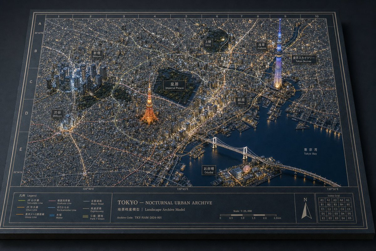
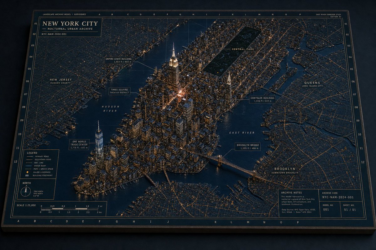
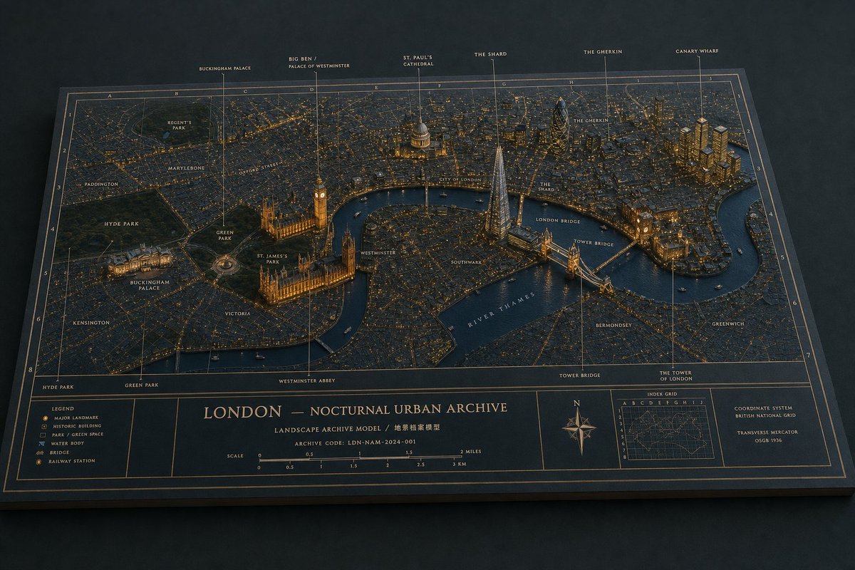
Create a cinematic 3D miniature architectural diorama map of {argument name="city" default="London"} at night, presented as a physical museum archive board on a dark tabletop. The board is a wide landscape rectangle viewed from an elevated oblique angle, with beveled edges, deep navy paper, thin bronze-gold cartographic linework, a coordinate grid, and warm amber city lights. Render a dense low-relief city street map with the river cutting through the middle, raised landmark buildings and bridges, realistic miniature textures, and a refined historical-atlas aesthetic. Use exactly 6 tall callout pins along the top edge labeled: “BUCKINGHAM PALACE”, “BIG BEN / PALACE OF WESTMINSTER”, “ST. PAUL’S CATHEDRAL”, “THE SHARD”, “THE GHERKIN”, and “CANARY WHARF”. Include additional small map labels across the city such as Regent’s Park, Paddington, Marylebone, Oxford Street, Hyde Park, Green Park, St. James’s Park, Buckingham Palace, Victoria, Westminster, Westminster Abbey, City of London, Southwark, The Shard, The Gherkin, London Bridge, Tower Bridge, The Tower of London, Bermondsey, Greenwich, Kensington, and “RIVER THAMES” following the water. Emphasize the raised landmarks: Buckingham Palace lit at lower left, the Palace of Westminster and Big Ben beside the river, St. Paul’s dome near the center, the Shard as a glowing glass pyramid tower, the Gherkin as a dark rounded tower, Canary Wharf as a cluster of golden high-rises, and Tower Bridge spanning the river. At the bottom of the board, create an information panel with exactly 5 main compartments: a legend box with small icons for major landmark, historic building, park/green space, water body, bridge, and railway station; a central title block reading “{argument name="map title" default="LONDON — NOCTURNAL URBAN ARCHIVE"}”; a scale bar marked in miles and kilometers; a compass rose with N; and a small index-grid inset plus coordinate-system notes. Add the subtitle “LANDSCAPE ARCHIVE MODEL / 地景档案模型” and archive code “{argument name="archive code" default="LDN-NAM-2024-001"}”. Lighting should be moody and nocturnal, with gold edge highlights, tiny illuminated windows, glowing roads, dark blue water, soft shadows, shallow depth of field, and highly detailed miniature craftsmanship. Keep all typography crisp, elegant, and atlas-like; avoid people, vehicles larger than tiny boats, modern UI elements, logos, or watermarks.Translations
伦敦夜景立体模型地图
enCreate a cinematic 3D miniature architectural diorama map of {argument name="city" default="London"} at night, presented as a physical museum archive board on a dark tabletop. The board is a wide landscape rectangle viewed from an elevated oblique angle, with beveled edges, deep navy paper, thin bronze-gold cartographic linework, a coordinate grid, and warm amber city lights. Render a dense low-relief city street map with the river cutting through the middle, raised landmark buildings and bridges, realistic miniature textures, and a refined historical-atlas aesthetic. Use exactly 6 tall callout pins along the top edge labeled: “BUCKINGHAM PALACE”, “BIG BEN / PALACE OF WESTMINSTER”, “ST. PAUL’S CATHEDRAL”, “THE SHARD”, “THE GHERKIN”, and “CANARY WHARF”. Include additional small map labels across the city such as Regent’s Park, Paddington, Marylebone, Oxford Street, Hyde Park, Green Park, St. James’s Park, Buckingham Palace, Victoria, Westminster, Westminster Abbey, City of London, Southwark, The Shard, The Gherkin, London Bridge, Tower Bridge, The Tower of London, Bermondsey, Greenwich, Kensington, and “RIVER THAMES” following the water. Emphasize the raised landmarks: Buckingham Palace lit at lower left, the Palace of Westminster and Big Ben beside the river, St. Paul’s dome near the center, the Shard as a glowing glass pyramid tower, the Gherkin as a dark rounded tower, Canary Wharf as a cluster of golden high-rises, and Tower Bridge spanning the river. At the bottom of the board, create an information panel with exactly 5 main compartments: a legend box with small icons for major landmark, historic building, park/green space, water body, bridge, and railway station; a central title block reading “{argument name="map title" default="LONDON — NOCTURNAL URBAN ARCHIVE"}”; a scale bar marked in miles and kilometers; a compass rose with N; and a small index-grid inset plus coordinate-system notes. Add the subtitle “LANDSCAPE ARCHIVE MODEL / 地景档案模型” and archive code “{argument name="archive code" default="LDN-NAM-2024-001"}”. Lighting should be moody and nocturnal, with gold edge highlights, tiny illuminated windows, glowing roads, dark blue water, soft shadows, shallow depth of field, and highly detailed miniature craftsmanship. Keep all typography crisp, elegant, and atlas-like; avoid people, vehicles larger than tiny boats, modern UI elements, logos, or watermarks.
伦敦夜景立体模型地图
zh-CN创建一个电影级的 3D 微缩建筑立体模型地图,展示 {argument name="city" default="London"} 的夜景,呈现为放置在深色桌面上的实体博物馆档案项目。该项目为宽幅横向矩形,采用高位斜角视角,带有斜切边缘、深海军蓝纸张、纤细的青铜金色制图线条、坐标网格以及温暖的琥珀色城市灯光。渲染一张密集的低浮雕城市街道地图,河流穿过中心,包含凸起的标志性建筑和桥梁、逼真的微缩纹理以及精致的历史地图集美感。在顶部边缘使用 6 个高大的标注针,分别标注:“BUCKINGHAM PALACE”、“BIG BEN / PALACE OF WESTMINSTER”、“ST. PAUL’S CATHEDRAL”、“THE SHARD”、“THE GHERKIN” 和 “CANARY WHARF”。在城市各处添加额外的小型地图标签,例如 Regent’s Park、Paddington、Marylebone、Oxford Street、Hyde Park、Green Park、St. James’s Park、Buckingham Palace、Victoria、Westminster、Westminster Abbey、City of London、Southwark、The Shard、The Gherkin、London Bridge、Tower Bridge、The Tower of London、Bermondsey、Greenwich、Kensington,以及沿河流标注的 “RIVER THAMES”。强调凸起的地标:左下角灯火通明的 Buckingham Palace、河畔的 Palace of Westminster 和 Big Ben、中心附近的 St. Paul’s 圆顶、作为发光玻璃金字塔塔楼的 The Shard、作为深色圆形塔楼的 The Gherkin、作为金色高层建筑群的 Canary Wharf,以及横跨河流的 Tower Bridge。在项目底部,创建一个包含 5 个主要区域的信息面板:一个图例框,包含主要地标、历史建筑、公园/绿地、水体、桥梁和火车站的小图标;一个中央标题块,写着 “{argument name="map title" default="LONDON — NOCTURNAL URBAN ARCHIVE"}”;一个以英里和公里为单位的比例尺;一个带有 N 指向的罗盘玫瑰;以及一个小型索引网格插图和坐标系统注释。添加副标题 “LANDSCAPE ARCHIVE MODEL / 地景档案模型” 和档案代码 “{argument name="archive code" default="LDN-NAM-2024-001"}”。灯光应呈现出忧郁的夜间氛围,带有金色边缘高光、微小的发光窗户、发光的道路、深蓝色水面、柔和的阴影、浅景深以及高度精细的微缩工艺。保持所有排版清晰、优雅且具有地图集风格;避免出现人物、大于微型船只的车辆、现代 UI 元素、徽标或水印。