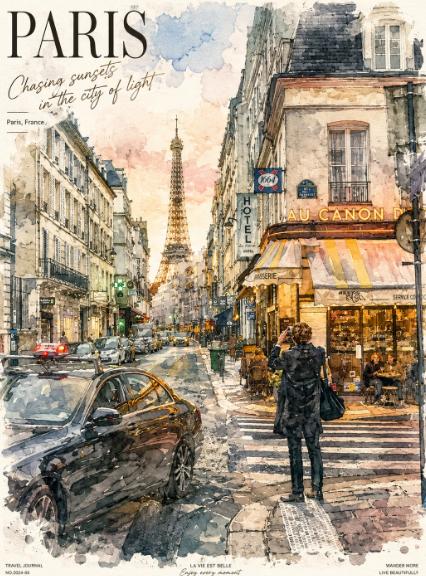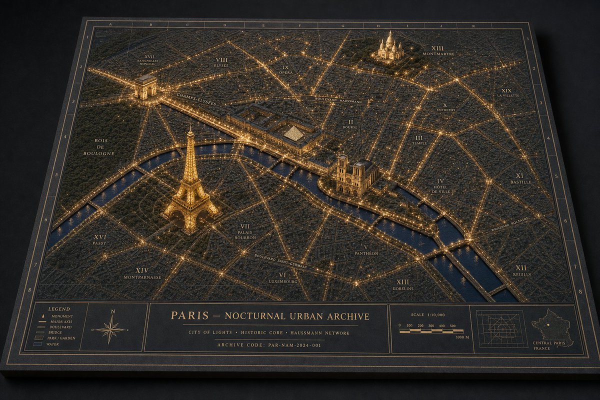
巴黎夜景立体模型地图
生成一张奢华的 3D 城市夜景发光地图,适用于微缩城市世界、制图学及建筑模型设计概念。
- Category
- Charts & Infographics
- Model
- GPT Image 2
- Creator
- Tia
- Source language
- en
- Source ID
- 23070
- Published
- May 28, 2026
Full prompt
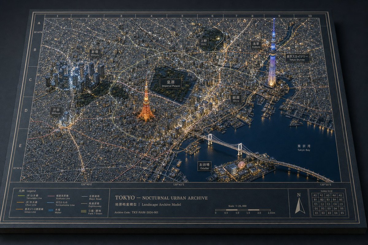
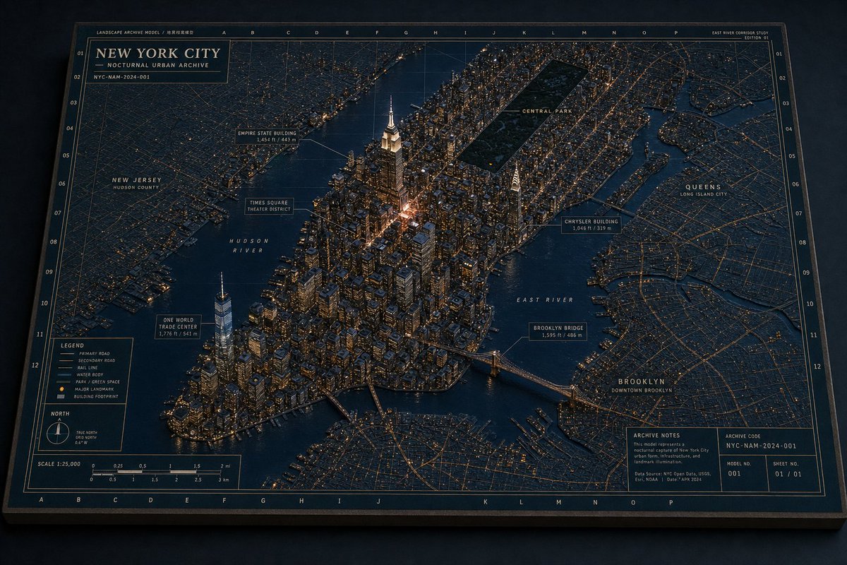
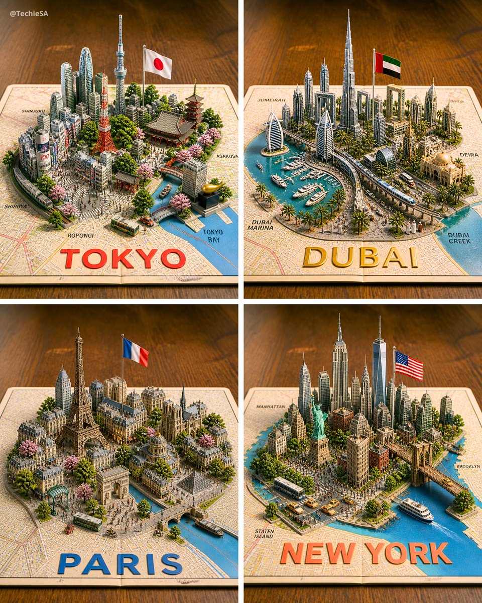
Goal: Create a premium 3D architectural diorama map of {argument name="city name" default="Paris"} at night, presented as a physical archival board titled {argument name="map title" default="PARIS — NOCTURNAL URBAN ARCHIVE"}.

Canvas: Landscape 3:2 view, photographed from an oblique overhead angle on a dark tabletop. The map is a thick rectangular black board with beveled edges, thin gold border lines, coordinate grid labels along the top and sides, and a refined museum-archive aesthetic.

Visual style: Dark navy and charcoal physical map texture, raised miniature city blocks, engraved streets, warm golden illumination tracing major boulevards and intersections, glossy deep-blue water, subtle cinematic shadows, high-detail miniature model craftsmanship, luxury cartography, brass-and-ink color palette.

Main map content: Show a nighttime miniature urban plan with illuminated road networks and raised landmark models. Include exactly 4 prominent 3D landmarks: 1) Eiffel Tower glowing gold in the lower-left/central-left area near the river, 2) Arc de Triomphe in the upper-left area with radiating avenues, 3) Notre-Dame-like cathedral on an island or riverbank near center-right, 4) Sacré-Cœur-like basilica on a hill in the upper-right area. Include one winding river crossing the map diagonally from left to lower-right, with multiple bridges, dark reflective water, and golden riverside lights.

Map labels: Use elegant small-cap serif labels in gold ink. Include exactly 20 arrondissement-style district labels: I Louvre, II Bourse, III Temple, IV Hôtel de Ville, V Panthéon, VI Luxembourg, VII Palais Bourbon, VIII Élysée, IX Opéra, X Entrepôt, XI Bastille, XII Reuilly, XIII Gobelins, XIV Montparnasse, XV Vaugirard, XVI Passy, XVII Batignolles-Monceau, XVIII Butte-Montmartre, XIX La Villette, XX Ménilmontant. Also label major routes and areas including Champs-Élysées, Boulevard Haussmann, Boulevard Saint-Germain, Boulevard Voltaire, Bois de Boulogne, and the River Seine.

Bottom information band: Add a wide cartographic footer divided into exactly 5 panels: 1) left legend box, 2) compass rose box, 3) large centered title block, 4) scale bar box, 5) right inset-map box. The legend box must list exactly 5 items: Monument, Major Axis, Boulevard, Bridge, Park / Garden, Water. The centered title block contains the map title, a subtitle reading "CITY OF LIGHTS · HISTORIC CORE · HAUSSMANN NETWORK", and an archive code reading "ARCHIVE CODE: PAR-NAM-2024-001". The scale panel shows "SCALE 1:10,000" and a 0 to 1000 m scale bar. The right inset panel shows a small grid map and a tiny outline map labeled "CENTRAL PARIS FRANCE".

Constraints: Keep all typography crisp and plausible, no people, no vehicles, no modern UI, no photoreal skyline beyond the raised map surface. The entire image should feel like directing a miniature nocturnal urban world: layered landmarks, physical map materials, coherent architectural-diorama language, and warm night lighting.
Translations
巴黎夜景立体模型地图
enGoal: Create a premium 3D architectural diorama map of {argument name="city name" default="Paris"} at night, presented as a physical archival board titled {argument name="map title" default="PARIS — NOCTURNAL URBAN ARCHIVE"}. Canvas: Landscape 3:2 view, photographed from an oblique overhead angle on a dark tabletop. The map is a thick rectangular black board with beveled edges, thin gold border lines, coordinate grid labels along the top and sides, and a refined museum-archive aesthetic. Visual style: Dark navy and charcoal physical map texture, raised miniature city blocks, engraved streets, warm golden illumination tracing major boulevards and intersections, glossy deep-blue water, subtle cinematic shadows, high-detail miniature model craftsmanship, luxury cartography, brass-and-ink color palette. Main map content: Show a nighttime miniature urban plan with illuminated road networks and raised landmark models. Include exactly 4 prominent 3D landmarks: 1) Eiffel Tower glowing gold in the lower-left/central-left area near the river, 2) Arc de Triomphe in the upper-left area with radiating avenues, 3) Notre-Dame-like cathedral on an island or riverbank near center-right, 4) Sacré-Cœur-like basilica on a hill in the upper-right area. Include one winding river crossing the map diagonally from left to lower-right, with multiple bridges, dark reflective water, and golden riverside lights. Map labels: Use elegant small-cap serif labels in gold ink. Include exactly 20 arrondissement-style district labels: I Louvre, II Bourse, III Temple, IV Hôtel de Ville, V Panthéon, VI Luxembourg, VII Palais Bourbon, VIII Élysée, IX Opéra, X Entrepôt, XI Bastille, XII Reuilly, XIII Gobelins, XIV Montparnasse, XV Vaugirard, XVI Passy, XVII Batignolles-Monceau, XVIII Butte-Montmartre, XIX La Villette, XX Ménilmontant. Also label major routes and areas including Champs-Élysées, Boulevard Haussmann, Boulevard Saint-Germain, Boulevard Voltaire, Bois de Boulogne, and the River Seine. Bottom information band: Add a wide cartographic footer divided into exactly 5 panels: 1) left legend box, 2) compass rose box, 3) large centered title block, 4) scale bar box, 5) right inset-map box. The legend box must list exactly 5 items: Monument, Major Axis, Boulevard, Bridge, Park / Garden, Water. The centered title block contains the map title, a subtitle reading "CITY OF LIGHTS · HISTORIC CORE · HAUSSMANN NETWORK", and an archive code reading "ARCHIVE CODE: PAR-NAM-2024-001". The scale panel shows "SCALE 1:10,000" and a 0 to 1000 m scale bar. The right inset panel shows a small grid map and a tiny outline map labeled "CENTRAL PARIS FRANCE". Constraints: Keep all typography crisp and plausible, no people, no vehicles, no modern UI, no photoreal skyline beyond the raised map surface. The entire image should feel like directing a miniature nocturnal urban world: layered landmarks, physical map materials, coherent architectural-diorama language, and warm night lighting.
巴黎夜景立体模型地图
zh-CN目标:创建一个 {argument name="city name" default="巴黎"} 的高端 3D 建筑模型地图夜景,呈现为一块名为 {argument name="map title" default="PARIS — NOCTURNAL URBAN ARCHIVE"} 的实体档案项目。 画布:横向 3:2 视角,从深色桌面上的倾斜俯视角度拍摄。地图为一块带有斜角边缘的厚实黑色矩形项目,配有金色细边框、顶部和侧面的坐标网格标签,呈现出精致的博物馆档案美学。 视觉风格:深海军蓝与炭灰色的实体地图质感,凸起的微缩城市街区,雕刻的街道,勾勒出主要大道和交叉路口的温暖金色灯光,光泽感深蓝色水域,微妙的电影级阴影,高细节的微缩模型工艺,奢华制图风格,黄铜与墨色的配色方案。 主要地图内容:展示一张带有发光道路网络和凸起地标模型的夜间微缩城市规划图。包含 4 个显著的 3D 地标:1) 左下/中左区域靠近河流处金光闪闪的埃菲尔铁塔,2) 左上区域带有放射状大道的凯旋门,3) 中右侧岛屿或河岸上类似巴黎圣母院的大教堂,4) 右上角山丘上类似圣心大教堂的巴西利卡。包含一条从左侧斜向右下角贯穿地图的蜿蜒河流,配有多座桥梁、深色反光水面和金色的河岸灯光。 地图标签:使用优雅的金色墨水小写衬线字体标签。包含 20 个巴黎区级标签:I 卢浮宫区 (Louvre)、II 交易所区 (Bourse)、III 圣殿区 (Temple)、IV 市政厅区 (Hôtel de Ville)、V 先贤祠区 (Panthéon)、VI 卢森堡区 (Luxembourg)、VII 波旁宫区 (Palais Bourbon)、VIII 爱丽舍区 (Élysée)、IX 歌剧院区 (Opéra)、X 仓库区 (Entrepôt)、XI 巴士底区 (Bastille)、XII 勒伊区 (Reuilly)、XIII 戈布兰区 (Gobelins)、XIV 蒙帕纳斯区 (Montparnasse)、XV 沃吉拉尔区 (Vaugirard)、XVI 帕西区 (Passy)、XVII 巴蒂诺尔-蒙索区 (Batignolles-Monceau)、XVIII 蒙马特高地区 (Butte-Montmartre)、XIX 拉维莱特区 (La Villette)、XX 梅尼蒙当区 (Ménilmontant)。同时标注主要路线和区域,包括香榭丽舍大街 (Champs-Élysées)、奥斯曼大道 (Boulevard Haussmann)、圣日耳曼大道 (Boulevard Saint-Germain)、伏尔泰大道 (Boulevard Voltaire)、布洛涅森林 (Bois de Boulogne) 以及塞纳河 (River Seine)。 底部信息栏:添加一个宽阔的制图页脚,分为 5 个面板:1) 左侧图例框,2) 指北针框,3) 居中的大型标题块,4) 比例尺框,5) 右侧插图框。图例框必须列出 5 个项目:纪念碑、主轴线、大道、桥梁、公园/花园、水域。居中的标题块包含地图标题、副标题“CITY OF LIGHTS · HISTORIC CORE · HAUSSMANN NETWORK”以及档案代码“ARCHIVE CODE: PAR-NAM-2024-001”。比例尺面板显示“SCALE 1:10,000”及 0 到 1000 米的比例尺条。右侧插图面板显示一张小型网格地图和一个标有“CENTRAL PARIS FRANCE”的微型轮廓图。 约束条件:保持所有排版清晰且合理,画面中不得出现人物、车辆、现代 UI,也不得出现凸起地图表面之外的写实天际线。整张图像应给人一种掌控微缩夜间城市世界的感觉:层叠的地标、真实的地图材质、连贯的建筑模型语言以及温暖的夜间照明。