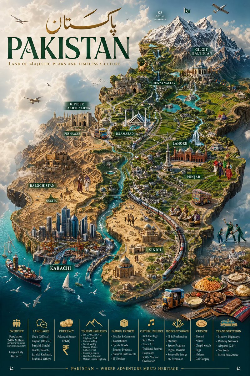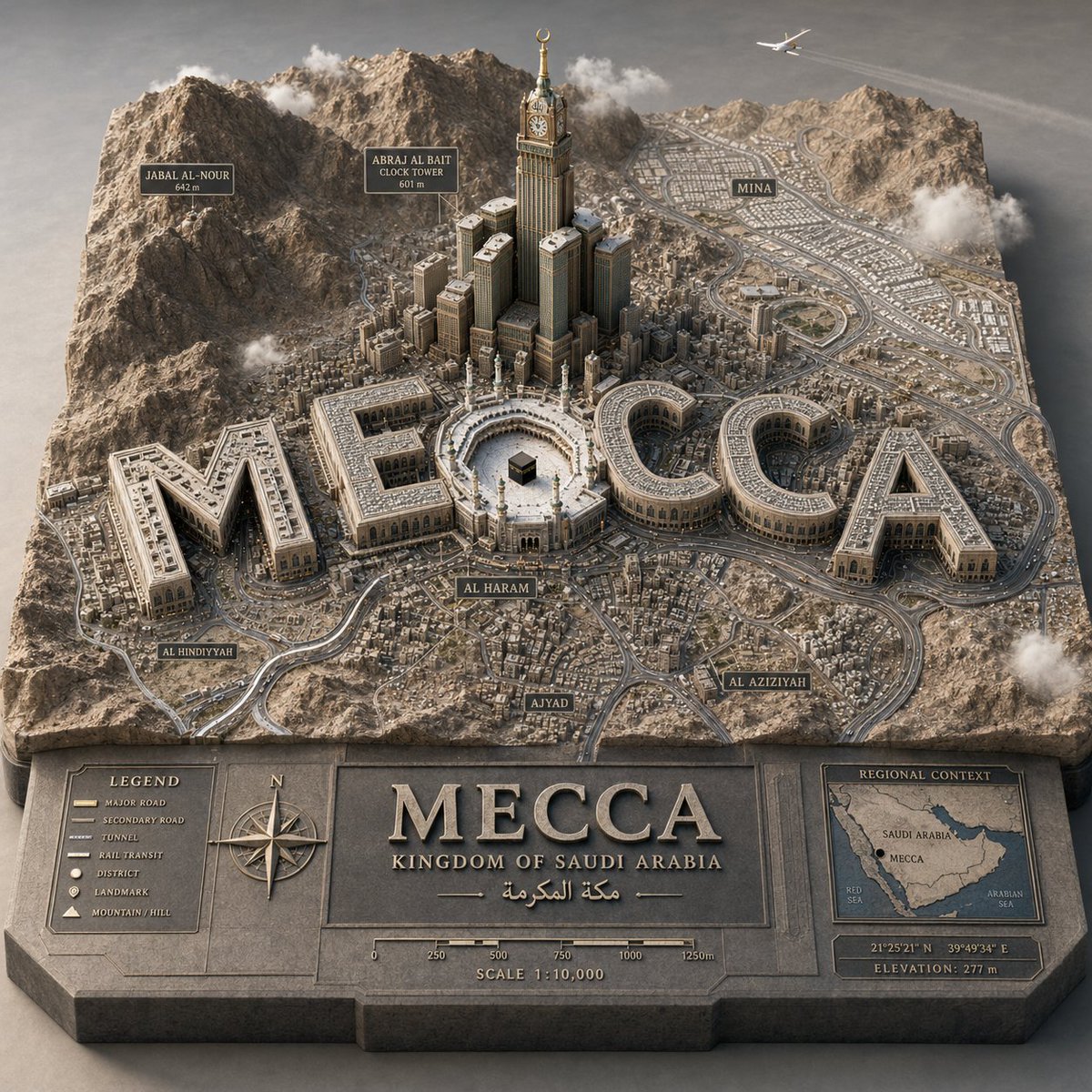
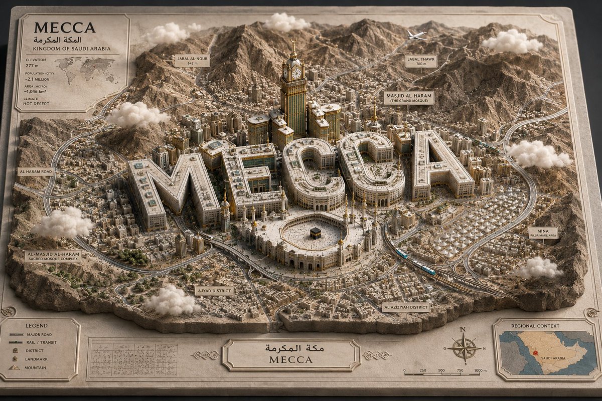
3D 地图城市立体模型
一个复杂的参数化场景图提示词,用于生成高端 3D 城市浮雕地图,并将地标性文字融入建筑设计中。
- Category
- Charts & Infographics
- Model
- GPT Image 2
- Creator
- Gadgetify
- Source language
- en
- Source ID
- 19685
- Published
- May 11, 2026
Full prompt
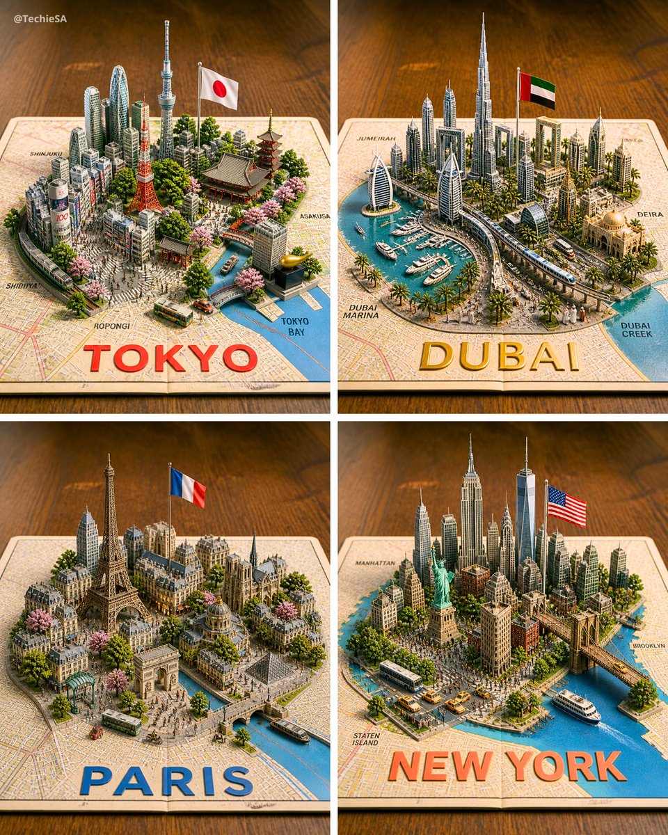
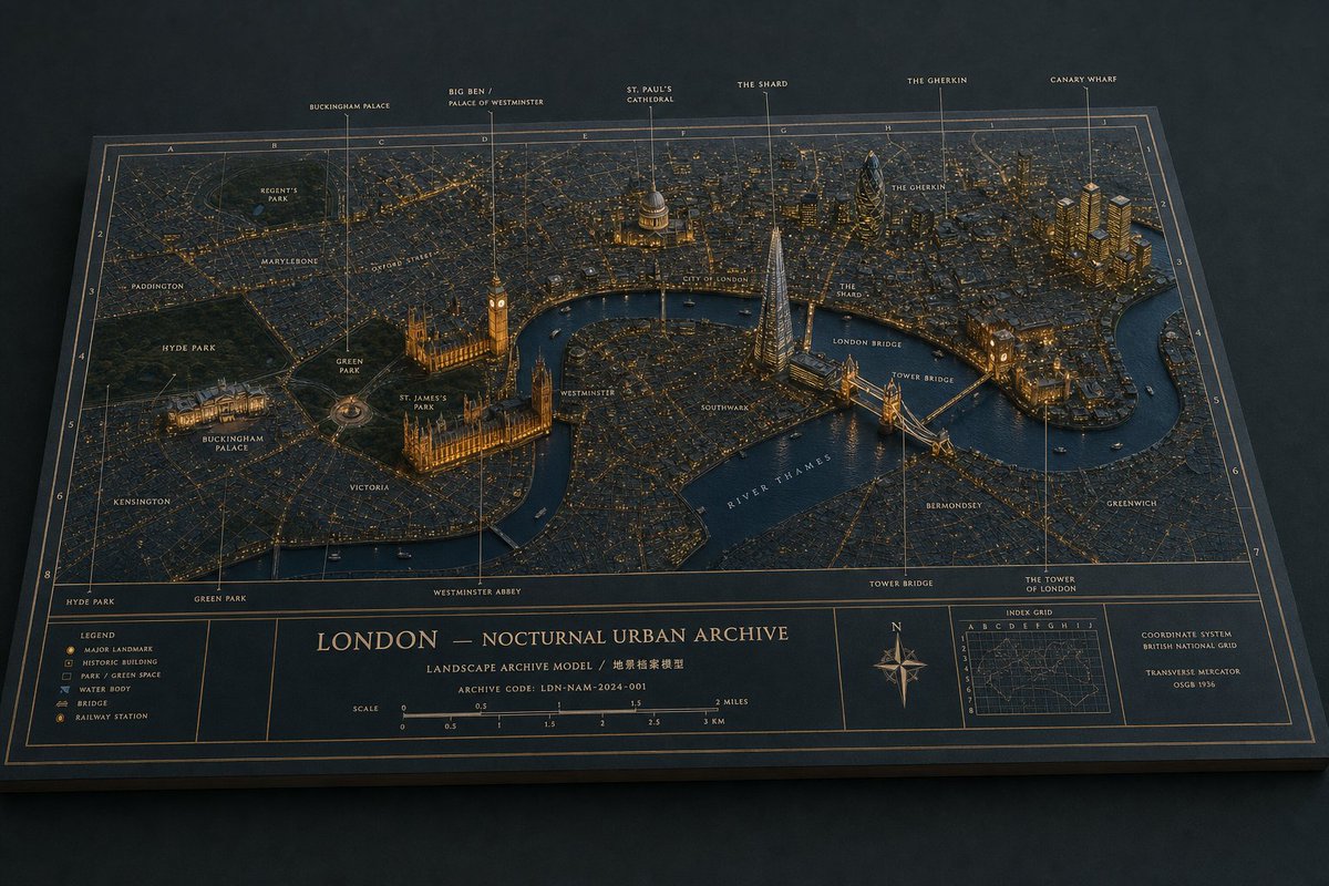
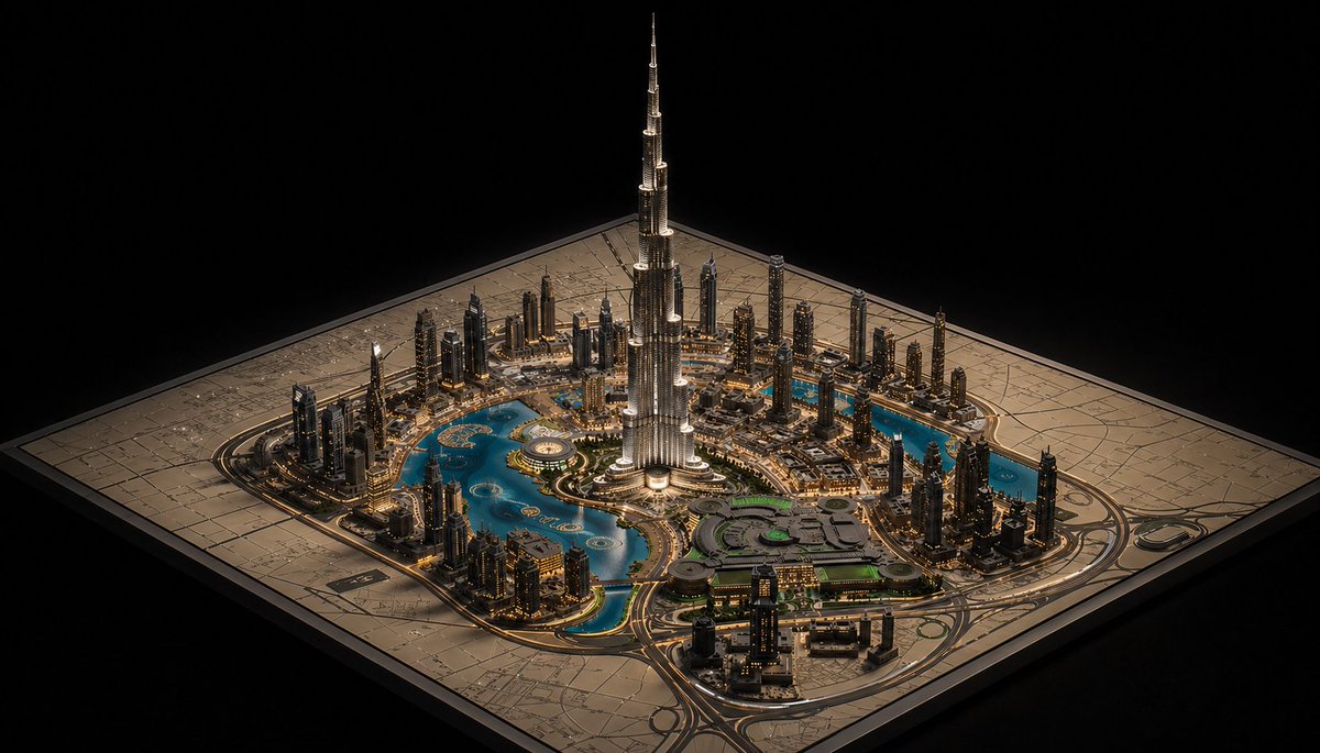
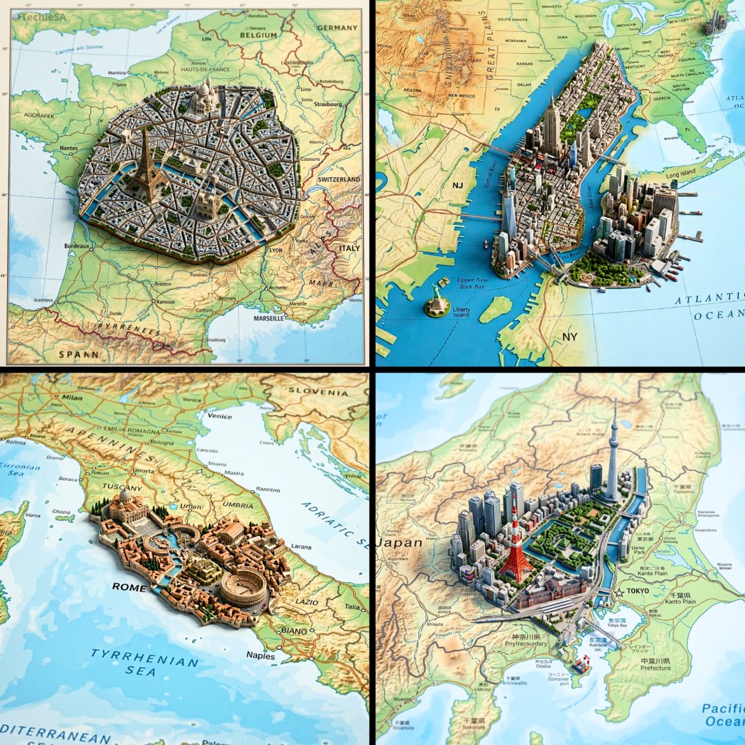
PYTHON_SCENE_GRAPH :: PARAMETRIC_CITY_RELIEF class Variables: city = "{argument name="city" default="[CITY]"}" city_name_text = "{argument name="city name" default="literal city name from input"}" region_context = "infer country, terrain, climate, culture, urban identity" topography = "infer mountains, rivers, coastlines, plains, islands, deserts, hills" urban_grid = "infer district density, roads, transit corridors, urban pattern" landmarks = "infer landmark_set(city)" signature_core = "infer most symbolic central landmark or public space" style = "luxury 3D cartographic city model" class TerrainSlab: form = "thick raised cutout map base" surface = Variables.topography edges = "engraved title panel, legend, compass, scale, inset regional map" material = "matte stone/plaster/cartographic model material" class CityTypography: text = Variables. city_name_text form = "monumental 3D letters" function = "each letter is an inhabitable building mass" placement = "integrated into city map, not floating" rule = "word must remain readable from aerial view" class UrbanLayer: roads = Variables.urban_grid districts = "infer neighborhoods and density zones" landmarks = Variables.landmarks core = Variables.signature_core labels = "derive place labels from city geography" class Atmosphere: camera = "elevated three-quarter macro" lighting = "soft premium studio daylight" details = "vehicles, clouds, aircraft, trees, people only if appropriate" def render(): return """ Render {argument name="target city" default="[CITY]"} as a raised terrain-map diorama where the city name becomes monumental architecture, surrounded by inferred geography, landmarks, labels, roads, and atlas-style cartographic details. """Translations
3D 地图城市立体模型
enPYTHON_SCENE_GRAPH :: PARAMETRIC_CITY_RELIEF class Variables: city = "{argument name="city" default="[CITY]"}" city_name_text = "{argument name="city name" default="literal city name from input"}" region_context = "infer country, terrain, climate, culture, urban identity" topography = "infer mountains, rivers, coastlines, plains, islands, deserts, hills" urban_grid = "infer district density, roads, transit corridors, urban pattern" landmarks = "infer landmark_set(city)" signature_core = "infer most symbolic central landmark or public space" style = "luxury 3D cartographic city model" class TerrainSlab: form = "thick raised cutout map base" surface = Variables.topography edges = "engraved title panel, legend, compass, scale, inset regional map" material = "matte stone/plaster/cartographic model material" class CityTypography: text = Variables. city_name_text form = "monumental 3D letters" function = "each letter is an inhabitable building mass" placement = "integrated into city map, not floating" rule = "word must remain readable from aerial view" class UrbanLayer: roads = Variables.urban_grid districts = "infer neighborhoods and density zones" landmarks = Variables.landmarks core = Variables.signature_core labels = "derive place labels from city geography" class Atmosphere: camera = "elevated three-quarter macro" lighting = "soft premium studio daylight" details = "vehicles, clouds, aircraft, trees, people only if appropriate" def render(): return """ Render {argument name="target city" default="[CITY]"} as a raised terrain-map diorama where the city name becomes monumental architecture, surrounded by inferred geography, landmarks, labels, roads, and atlas-style cartographic details. """
3D 地图城市立体模型
zh-CNPYTHON_SCENE_GRAPH :: PARAMETRIC_CITY_RELIEF class Variables: city = "{argument name="city" default="[CITY]"}" city_name_text = "{argument name="city name" default="literal city name from input"}" region_context = "推断国家、地形、气候、文化、城市特征" topography = "推断山脉、河流、海岸线、平原、岛屿、沙漠、丘陵" urban_grid = "推断区域密度、道路、交通走廊、城市格局" landmarks = "推断 landmark_set(city)" signature_core = "推断最具象征意义的中心地标或公共空间" style = "奢华 3D 地图城市模型" class TerrainSlab: form = "厚实凸起的镂空地图底座" surface = Variables.topography edges = "雕刻标题面板、图例、指南针、比例尺、插图区域地图" material = "哑光石材/石膏/地图模型材质" class CityTypography: text = Variables. city_name_text form = "纪念碑式 3D 字体" function = "每个字母均为可居住的建筑体量" placement = "整合于城市地图中,非悬浮" rule = "文字必须在俯瞰视角下保持可读性" class UrbanLayer: roads = Variables.urban_grid districts = "推断社区和密度区" landmarks = Variables.landmarks core = Variables.signature_core labels = "根据城市地理衍生地点标签" class Atmosphere: camera = "高位四分之三微距视角" lighting = "柔和高级摄影棚日光" details = "车辆、云层、飞机、树木,仅在合适时显示人物" def render(): return """ 将 {argument name="target city" default="[CITY]"} 渲染为凸起的地形图立体模型,其中城市名称转化为纪念碑式建筑,并辅以推断的地理环境、地标、标签、道路及地图集风格的制图细节。 """