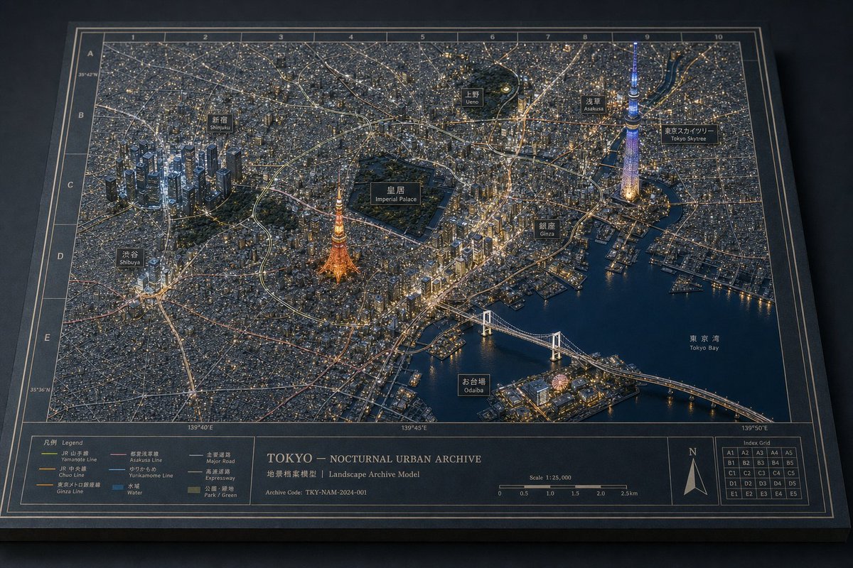
伦敦夜间城市档案立体模型
生成一张博物馆风格的伦敦夜间 3D 浮雕地图,包含地标、地图注释、图例、比例尺以及档案展示细节。
- Category
- Charts & Infographics
- Model
- GPT Image 2
- Creator
- Tia
- Source language
- en
- Source ID
- 20068
- Published
- May 13, 2026
Full prompt
Goal: Create a cinematic physical museum-diorama map titled {argument name="city archive title" default="LONDON — NOCTURNAL URBAN ARCHIVE"}, showing {argument name="city" default="London"} at night as a raised 3D architectural archive model on a flat printed cartographic board.

Canvas: Wide horizontal 16:9 image, three-quarter overhead view, dark studio background, the board seen in perspective like a premium museum exhibit or archival planning model. Use a restrained nocturnal palette: deep blue-black paper, navy water, charcoal city blocks, warm amber streetlights, muted gold linework, and subtle cool highlights.

Main diorama: A detailed miniature city map with raised matte buildings, parks, bridges, and river geometry. The River Thames snakes across the center in dark blue, labeled “RIVER THAMES.” Dense street grids glow with tiny amber lights. Major landmarks are slightly taller, more sculptural, and individually illuminated, with thin vertical annotation leader lines rising to labels.

Visible landmark annotations: Include exactly 6 large top-edge labels with leader lines: “BUCKINGHAM PALACE,” “BIG BEN / PALACE OF WESTMINSTER,” “ST. PAUL’S CATHEDRAL,” “THE SHARD,” “THE GHERKIN,” and “CANARY WHARF.” Also include smaller map labels for these 14 places: Regent’s Park, Paddington, Marylebone, Oxford Street, Hyde Park, Green Park, St. James’s Park, Buckingham Palace, Victoria, Westminster, City of London, Southwark, Bermondsey, and Greenwich.

Key raised structures: Emphasize exactly 7 landmark model groups: Buckingham Palace at lower left with glowing frontage, Palace of Westminster and Big Ben beside the river, St. Paul’s Cathedral with a domed roof, The Shard as a bright triangular glass tower, The Gherkin as a dark bullet-shaped tower, Tower Bridge crossing the river in warm light, and Canary Wharf as a cluster of tall golden-lit towers at upper right.

Map and border system: Add a precise archival grid overlay with letters along the top edge and numbers along the side edges, fine gold coordinate lines, double-line border, and thin annotation ticks. Keep the paper surface tactile with visible grain, slight bevel thickness, and realistic cast shadows from raised buildings and label lines.

Bottom information band: Create exactly 5 boxed panels along the bottom. Panel 1 is a legend with exactly 6 icon rows: Major Landmark, Historic Building, Park / Green Space, Water Body, Bridge, Railway Station. Panel 2 is a narrow empty divider/label strip. Panel 3 is the central title block with the title, a subtitle reading “LANDSCAPE ARCHIVE MODEL / 地景檔案模型,” an archive code reading {argument name="archive code" default="LDN-NAM-2024-001"}, and a dual scale bar in miles and kilometers. Panel 4 contains a decorative compass rose with N/E/S/W markings. Panel 5 contains an “INDEX GRID” mini-map and a small coordinate-system note reading “COORDINATE SYSTEM / BRITISH NATIONAL GRID / TRANSVERSE MERCATOR / OSGB 1936.”

Lighting and material style: Photorealistic editorial render, macro miniature depth, museum-grade craftsmanship, warm amber city illumination against cool blue shadows, matte paper and painted resin buildings, crisp gold typography, shallow atmospheric vignette, no people, no vehicles except tiny indistinct boats on the river, no watermark.

Constraints: Keep the composition consistent and legible as a single physical archive board. Use exact counts for the 6 large top labels, 14 smaller place labels, 7 raised landmark groups, 5 bottom panels, and 6 legend rows. Preserve the archival cartographic aesthetic rather than a modern digital UI.
Translations
伦敦夜间城市档案立体模型
enGoal: Create a cinematic physical museum-diorama map titled {argument name="city archive title" default="LONDON — NOCTURNAL URBAN ARCHIVE"}, showing {argument name="city" default="London"} at night as a raised 3D architectural archive model on a flat printed cartographic board. Canvas: Wide horizontal 16:9 image, three-quarter overhead view, dark studio background, the board seen in perspective like a premium museum exhibit or archival planning model. Use a restrained nocturnal palette: deep blue-black paper, navy water, charcoal city blocks, warm amber streetlights, muted gold linework, and subtle cool highlights. Main diorama: A detailed miniature city map with raised matte buildings, parks, bridges, and river geometry. The River Thames snakes across the center in dark blue, labeled “RIVER THAMES.” Dense street grids glow with tiny amber lights. Major landmarks are slightly taller, more sculptural, and individually illuminated, with thin vertical annotation leader lines rising to labels. Visible landmark annotations: Include exactly 6 large top-edge labels with leader lines: “BUCKINGHAM PALACE,” “BIG BEN / PALACE OF WESTMINSTER,” “ST. PAUL’S CATHEDRAL,” “THE SHARD,” “THE GHERKIN,” and “CANARY WHARF.” Also include smaller map labels for these 14 places: Regent’s Park, Paddington, Marylebone, Oxford Street, Hyde Park, Green Park, St. James’s Park, Buckingham Palace, Victoria, Westminster, City of London, Southwark, Bermondsey, and Greenwich. Key raised structures: Emphasize exactly 7 landmark model groups: Buckingham Palace at lower left with glowing frontage, Palace of Westminster and Big Ben beside the river, St. Paul’s Cathedral with a domed roof, The Shard as a bright triangular glass tower, The Gherkin as a dark bullet-shaped tower, Tower Bridge crossing the river in warm light, and Canary Wharf as a cluster of tall golden-lit towers at upper right. Map and border system: Add a precise archival grid overlay with letters along the top edge and numbers along the side edges, fine gold coordinate lines, double-line border, and thin annotation ticks. Keep the paper surface tactile with visible grain, slight bevel thickness, and realistic cast shadows from raised buildings and label lines. Bottom information band: Create exactly 5 boxed panels along the bottom. Panel 1 is a legend with exactly 6 icon rows: Major Landmark, Historic Building, Park / Green Space, Water Body, Bridge, Railway Station. Panel 2 is a narrow empty divider/label strip. Panel 3 is the central title block with the title, a subtitle reading “LANDSCAPE ARCHIVE MODEL / 地景檔案模型,” an archive code reading {argument name="archive code" default="LDN-NAM-2024-001"}, and a dual scale bar in miles and kilometers. Panel 4 contains a decorative compass rose with N/E/S/W markings. Panel 5 contains an “INDEX GRID” mini-map and a small coordinate-system note reading “COORDINATE SYSTEM / BRITISH NATIONAL GRID / TRANSVERSE MERCATOR / OSGB 1936.” Lighting and material style: Photorealistic editorial render, macro miniature depth, museum-grade craftsmanship, warm amber city illumination against cool blue shadows, matte paper and painted resin buildings, crisp gold typography, shallow atmospheric vignette, no people, no vehicles except tiny indistinct boats on the river, no watermark. Constraints: Keep the composition consistent and legible as a single physical archive board. Use exact counts for the 6 large top labels, 14 smaller place labels, 7 raised landmark groups, 5 bottom panels, and 6 legend rows. Preserve the archival cartographic aesthetic rather than a modern digital UI.
伦敦夜间城市档案立体模型
zh-CN目标:创建一个名为 {argument name="city title" default="LONDON — NOCTURNAL URBAN ARCHIVE"} 的电影级实体博物馆立体模型地图,将伦敦呈现为放置在平面地图项目上的 3D 建筑档案模型。 画布:宽屏 16:9 水平图像,四分之三俯视视角,整个项目在深色哑光桌面上清晰可见。使用克制的夜间色调:深海军蓝纸张、炭灰色街道、温暖的琥珀色城市灯光、柔和的金色地图线条、深蓝色水域以及精致的灰白色字体。 主场景:构建一个伦敦市中心的精细微缩浮雕地图,泰晤士河在左下方和右侧蜿蜒流过。街道应呈现为密集的细线网格,并点缀着数千盏微小的暖色灯光。公园是深绿色的凹陷区域。建筑物为低矮的哑光凸起,关键地标则更高、更具雕塑感。让模型具有触感和实体感:纸张纹理、斜切的项目边缘、投影、河上的微型船只以及逼真的博物馆展示照明。 地标与标注:包含 6 个垂直向上的注释标注,带有细金色引导线和小号大写标签:1) Buckingham Palace,2) Big Ben / Palace of Westminster,3) St. Paul's Cathedral,4) The Shard,5) The Gherkin,6) Canary Wharf。将它们从左到右放置在顶部边缘。泰晤士河附近的威斯敏斯特宫和 Big Ben 需有温暖的照明,St. Paul's Cathedral 带有发光的圆顶,The Shard 为高耸尖锐的玻璃尖塔,The Gherkin 为圆润的子弹形塔楼,Canary Wharf 为一组金色高层建筑,Tower Bridge 为横跨泰晤士河的照明桥梁。 地图标签:在地图上直接添加小号大写字母的街区和地点标签,包括 Regent's Park、Marylebone、Oxford Street、Paddington、Hyde Park、Green Park、St. James's Park、Buckingham Palace、Kensington、Victoria、Westminster、Southwark、City of London、London Bridge、Tower Bridge、Bermondsey、Greenwich、River Thames、The Shard、The Gherkin 和 The Tower of London。使用符合档案地图美学的柔和奶油色或浅金色字体。 网格与边框系统:叠加一个精确的地图集风格索引网格,顶部为字母,侧面为数字。使用细金色网格线、双线边框和雕刻般的档案绘图风格。项目应看起来像一个高级景观档案模型,而非数字截图。 底部信息栏:保留一个全宽的地图页脚,分为多个框架面板。左侧面板包含一个包含 6 个符号条目的图例:主要地标、历史建筑、公园/绿地、水体、桥梁、火车站。中心面板包含大标题 {argument name="city title" default="LONDON — NOCTURNAL URBAN ARCHIVE"}、副标题 {argument name="subtitle text" default="LANDSCAPE ARCHIVE MODEL / 地景档案模型"}、档案代码 {argument name="archive code" default="ARCHIVE CODE: LDN-NAM-2024-001"} 以及标注为英里和公里的比例尺(0 到 3 英里和 0 到 3 公里)。右侧包含一个罗盘玫瑰、一个小插图索引网格地图以及坐标说明 {argument name="coordinate note" default="COORDINATE SYSTEM — BRITISH NATIONAL GRID — TRANSVERSE MERCATOR — OSGB 1936"}。 风格限制:超精细的编辑级产品摄影,逼真的微缩材料,清晰但微小的可读字体,冷海军蓝阴影下的暖琥珀色高光,仅在极边缘处有浅景深,无人像,无现代 UI,无水印,除指定数量外,不得添加额外的图例或地标标注。